Flying Expedition Across the Kimberley


mfh-map


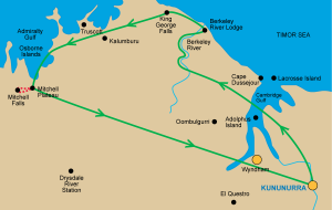
Ok so this was the big day for flying. Up at 5am, cooked breakfast and off to the Kununurra Airport. All lined up for the aircraft, an Airvan manufactured in Gippsland, seats 8 including the pilot and has a high wing which is good for visibility on scenic flights. Turns out the pilot was only 23 but he did a great job. He carefully seated his passengers (presumably for weight distribution) and, to my surprise, put me in the co pilots seat so I was going to have great views. We headed north west and north of Wyndham taking in the enormous river delta made by the combining of 5 rivers, Pentacost, Ord, Durack, King and Forrest.

Ord Valley

Image 1 of 15

Ord Valley from the air just out of Kununurra Airfield


Then on round the coast inland to the Berkeley Riv and the Berkeley River Resort positioned on large sand dunes adjoining the beach (runs to $1600 a night min 3 nights I believe) but a spectacular wilderness location. Next highlight was the King George Falls and Gorge.

Coastline SE of Berkeley River

Image 1 of 21

Coastline SE of Berkeley River

On past Truscott Airfield which is still busy today, but was hidden from the Japanese in WW2, they bombed Kulumburu instead. Truscott is still used to service many gas and oil fields in the Timor Sea.
The Osborn Islands provide a very pretty view and are surrounded by pearl beds strung on large nets visible from the air.

Napier Broome Bay

Image 1 of 18

Napier Broome Bay


Landing on a dirt strip at Mitchell Plateau was uneventful. Lots of containers and fuel drums. One of the containers housed our next mode of transport, a modified Toyota Troop Carrier. Wes the pilot was kept very busy getting the truck out as well as serving us all morning tea. Then a very bumpy ride for 30 mins to the Mitchell Falls campground.

We were provided lunch to carry along with water and began our class 5 hike that is clamber over rocks and through the beautiful bush taking in Aboriginal rock art and various perspectives on the Merton Creek.

Rock Art 1

Image 1 of 12

Rock Art 1

.We first admired the Mitchell Falls from on top of the remarkable drop and then walked around to the other side of the gorge and a most spectacular view back toward the falls. The Mitchell River Falls are truly spectacular. On the way some of us had a dip in the river and lunch while admiring the Mitchell Falls.

As we stood by a relatively flat rock area adjacent to the river in came 2 helicopters to take us back to the campground with doors off so as to provide uninterrupted view of the entire vista.

Mitchell Falls - face on

Image 1 of 26

Mitchell Falls taken from lunch spot on opposite side of gorge.


We bounced our way back to the airfield and on the way came across a camper trailer, looked quite new, but the entire axle and suspension was all but completely torn adrift a reminder of how taxing these roads can be on vehicles.

The pilot worked hard preparing the aircraft and packing up, before we took to the air and followed a direct route back to Kununurra across this vast sparsly populated region, I only saw one road until we were back near Wyndham. But I did feel very satisfied with my day of flying and hiking.

Lining up for takeoff.

Image 4 of 30


Leave a Reply

Your email address will not be published. Required fields are marked *